Day 122: Another Fire?

August 17, 2017

Total daily miles: 26.4 miles
Total PCT miles: 1944.8
Start: mile 2325.3
End: mile 2351.7
Total elevation gain/loss: 3448.5/4677.5 ft

When we woke up this morning, the impressive views that had surrounded us when we went to sleep had disappeared. We were now in the clouds. The trail was barely visible in the distance as it wrapped around the mountain. Unsurprisingly, it was also cold. I set off once again wearing my rain jacket, beanie, buff, and even gloves to start the day.

DSC04111

Fog City Trail — aptly named and a reminder of home (San Francisco’s nickname is Fog City).

DSC04112

Continue reading

Day 121: Mt. Rainier views to Chinook Pass

**We’re making a push to finish recording our memories from our 2017 PCT adventure.  This post is from my collection of fully-written and half-written blog posts that are still waiting to see the light of day (along with a few days with just mileage notations and pictures… and may remain that way).**

August 16, 2017

Total daily miles: 25.8 miles
Total PCT miles: 1918.4
Start: Pipe Lake (mile 2299.5)
End: mile 2325.3
Total elevation gain/loss: 4822.2/3874.3 ft

The strain of hiking 1900 miles at a recent pace of 25 miles a day seems to be catching up with my body. By 9pm last night, I was completely spent and practically asleep. When my alarm went off at 5:15, it seemed way too early to even think about getting up. It’s as though my body is now protesting the daily abuse it gets and demanding more rest in return. I guess the evenings of reading my kindle until 10pm have now passed.

DSC04077

If only we were at 2300 miles!

DSC04080

Blueberry pop tart versus blueberries…

Continue reading

Day 112: A Forced 30

August 7, 2017

Total daily miles: 30.0 miles

Total PCT miles: 1722.7

Start: mile 2099.6

End: mile 2129.6

Total elevation gain/loss: 5323.2/6481.6 ft

Well, another day that didn’t quite go as planned…  We started out this morning in what felt like a foggy haze.  I’m assuming that it was smoke from the Eagle Creek fire, but with fires both north and south of us now it’s hard to know for certain.

dsc03906

Our first couple of miles were all downhill.  We had a great view of a large waterfall in the distance, otherwise it felt like we were walking through an area that has seen a lot of erosion/rock slides.  Lots of exposed dirt cliffs!  After a few miles we hit the Sandy River (with a name like that we figured we wouldn’t be grabbing water from this source).  I’d seen some mixed info about how hard of a crossing it was, so I was pleased to see that it wasn’t the fast, thigh-high crossing that was reported.  Just a log crossing!  And by “just,” I mean that the logs were relatively narrow and I was super happy to have my poles, but I made it across with dry feet.  I’ll take it as a win. Continue reading

Day 109: Finishing the Mt. Jefferson Reroute

August 4, 2017

Total daily miles: 25.8 miles (15.1 miles PCT; 8.7 miles Hwy 22; 2 miles FR 4220)

Total PCT miles: 1645.2

Start: Whispering Falls Campground/Woodpecker Ridge Trail (mile 2026.8)

End: mile 2052.1

Total elevation gain/loss: 1366.8/2597.4 ft (PCT section only)

Today we faced the difficult decision of what to do about the fire reroute.  But first, figuring out what the fire reroute is after yesterday’s news that the entire Mt. Jefferson Wilderness is being (has been?) closed.  Easier said than done.

dsc03861

Our morning view.

Continue reading

Day 108: Too Close to the Fire

August 3, 2017

Total daily miles: 26.7 miles

Total PCT miles: 1619.9

Start: Rockpile Lake (mile 2012.3)

End: Whispering Falls Campground/Woodpecker Ridge Trail (mile 2026.8)

Total elevation gain/loss: 1935.7/3869.8 ft (PCT section only)

What a day!  Today did not go as planned.  Trying to get around the fire in the Mt. Jefferson Wilderness has left me physically and emotionally exhausted.  It’s one of the few days on trail where I feel like I could cry at the end of it.  This is a long one…

We got up extra early this morning with the hope of getting out of the smoke and on the fire alternate as quickly as possible.  The air was clearer this morning then it was last night.  I hoped that was a good sign of things to come.

dsc03841dsc03843

Continue reading

Day 107: Smokey Santiam Pass

August 2, 2017

Total daily miles: 13.9 miles

Total PCT miles: 1605.4

Start: Santiam Pass (mile 1998.4)

End: Rockpile Lake (mile 2012.3)

Total elevation gain/loss: 2910.4/1450.1 ft

I’ve learned enough by now to know that getting out of town is never fast and today was no different.  We said goodbye to Renee, who has been an awesome host.  She’s been so nice and full of energy, it’s been great to get to know her a bit.  Again, future hikers should definitely check out Recharge, especially if you’re in town during beer yoga!

dsc03825

Playtime with a dog makes Michael’s day.

Continue reading

Day 105: Bend Trail Magic

July 31, 2017

Total daily miles: 16.7 miles

Total PCT miles: 1291.5

Start: mile 1981.7

End: Santiam Pass (mile 1998.4)

Total elevation gain/loss: 1961/2371.4 ft

Despite being near the highway, I slept really well last night.  The best part was that my feet felt much better as we got going this morning than they did last night!  Which was a good thing, since we started with a stretch over more lava rock.

dsc03817

The other good news this morning is that the lava section was much shorter than I had feared.  Based on our map, it looked like we’d spend several miles walking over lava, but it ended up being a much shorter stint with much smaller lava rock than the end of the day yesterday.  It was still a slow start to the day and I was definitely happy to have waited, but it was over within a couple of miles and we largely stayed in the shade. Continue reading

Progress Update

As you may have noticed, we’ve fallen behind on getting blog entries posted. This delay has been due to a combination of factors, including the lack of decent internet connections in Northern California, Oregon, and Washington. We’re working on getting the rest of the entries up, but it might take awhile.

We wanted to let you in on some good news though: WE MADE IT TO CANADA!!!  


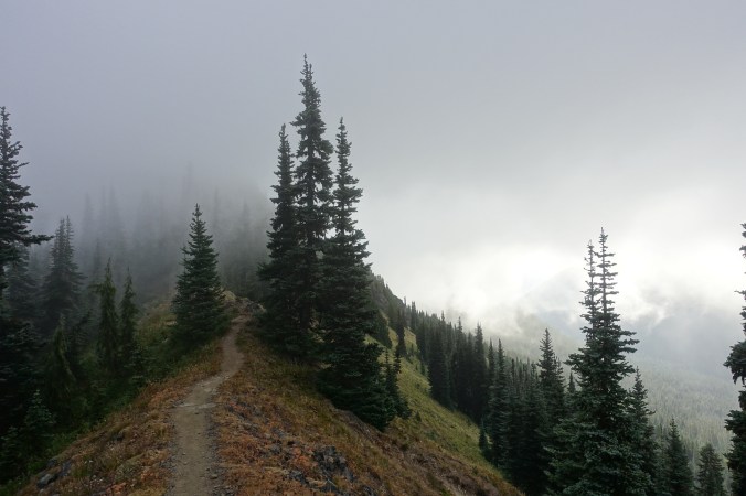
We arrived at the monument on September 3, 2017. For the most part, we beat out the fires in Oregon and Washington that are now blocking large sections of the trail. Our understanding is that Oregon is basically unhikeable right now and fire closures are affecting more and more of the trail in Washington. Our decision to skip the High Sierra now appears to have afforded us the opportunity to hike Oregon and Washington almost uninterrupted. A lucky break.

So, what’s next? We still have 407 miles of trail to hike in the Sierra. After reaching Canada, we hightailed it back to Independence to jump back on trail at Kearsarge Pass — the same spot we exited in early June. Our plan is to continue north until we reach Sierra City — our final piece of this year’s PCT puzzle. With the end in sight, we’re psyched to be heading back into the beautiful Sierra Nevada mountains. Our fingers are crossed that we won’t run into any further obstacles in the next few weeks. Wish us luck!

We expect that our internet access will be very limited in the next couple of weeks. We’ll try to get posts up when we can, but no guarantees. I’m still blogging and taking notes as I go though, and I can’t wait until our entire story is up for you to read. This has been a truly incredible experience.

Day 85: Into the Smokey Marble Mountains

July 11, 2017

Total daily miles: 15.5 miles

Total PCT miles: 1205.7

Start: Etna (mile 1597.2)

End: mile 1612.6

Total elevation gain/loss: 2905.8/2411.1 ft

Sleeping in is glorious! I think I made it to almost 8am this morning before the sunlight hit my tent and it started to heat up quickly. I think that my body really needed that extra sleep!

We packed up quickly and then enjoyed a breakfast of fresh fruit and muffins that we’d picked up from the grocery store. A nice change from fig bars and pop tarts! The pavilion area at the city park really is an ideal spot to hang out and I have to admit that I was surprised how easy it was to get quiet time for myself while staying at the park.  

Continue reading