August 3, 2017
Total daily miles: 26.7 miles
Total PCT miles: 1619.9
Start: Rockpile Lake (mile 2012.3)
End: Whispering Falls Campground/Woodpecker Ridge Trail (mile 2026.8)
Total elevation gain/loss: 1935.7/3869.8 ft (PCT section only)
What a day! Today did not go as planned. Trying to get around the fire in the Mt. Jefferson Wilderness has left me physically and emotionally exhausted. It’s one of the few days on trail where I feel like I could cry at the end of it. This is a long one…
We got up extra early this morning with the hope of getting out of the smoke and on the fire alternate as quickly as possible. The air was clearer this morning then it was last night. I hoped that was a good sign of things to come.


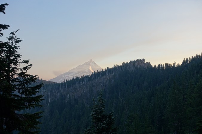
The trail soon opened up on a ridge line. It was immediately apparent why the sky seemed clearer as I was hit by gusts of wind headed west. This concerned me because we would be heading west from the trail too. A plume of smoke could be seen up ahead. The outline of Mt. Jefferson was also obscured by smoke. Smoke that we were walking toward.
Not looking too bad yet…

We briefly stopped at a pond near Shale Lake to grab water. While there, I spoke with another hiker who said that he’d had cell signal last night and had checked the fire report. No updates. The reroute was the same as what we’d been planning. The hiker wasn’t planning on exiting at Woodpecker trail like we were; instead, he was going to exit a couple of miles before at Pamelia Lake, which requires a special permit not covered by our PCT permit.

The smoke thickened after leaving the lake. I immediately began feeling apprehensive. We’ve hiked in heavy smoke before — when we hiked the JMT in 2015 there was significant wildfire smoke without incident. The difference was that this smoke was thicker and I could tell that it was only going to get worse. A helicopter circled in the distance. Its presence did nothing to calm my concerns. The fact that we hadn’t seen a single southbound hiker similarly did not put me at ease. Had the fire expanded? Had the area been evacuated?

Where did the surrounding mountains go?

Into the smoke we go…
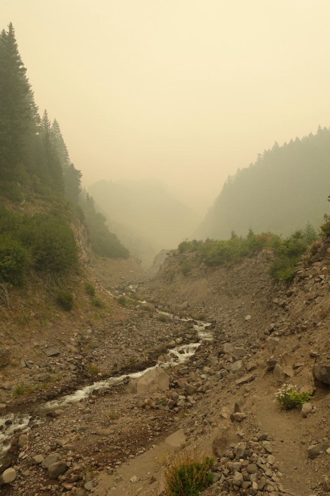
We quickly grabbed water at a rushing stream that was less than two miles from the Woodpecker Ridge trail turnoff that marked the beginning of the fire closure. The valley that the stream ran through was shrouded in thick smoke. I felt like we needed to move fast and stick together. We needed to get out of this.
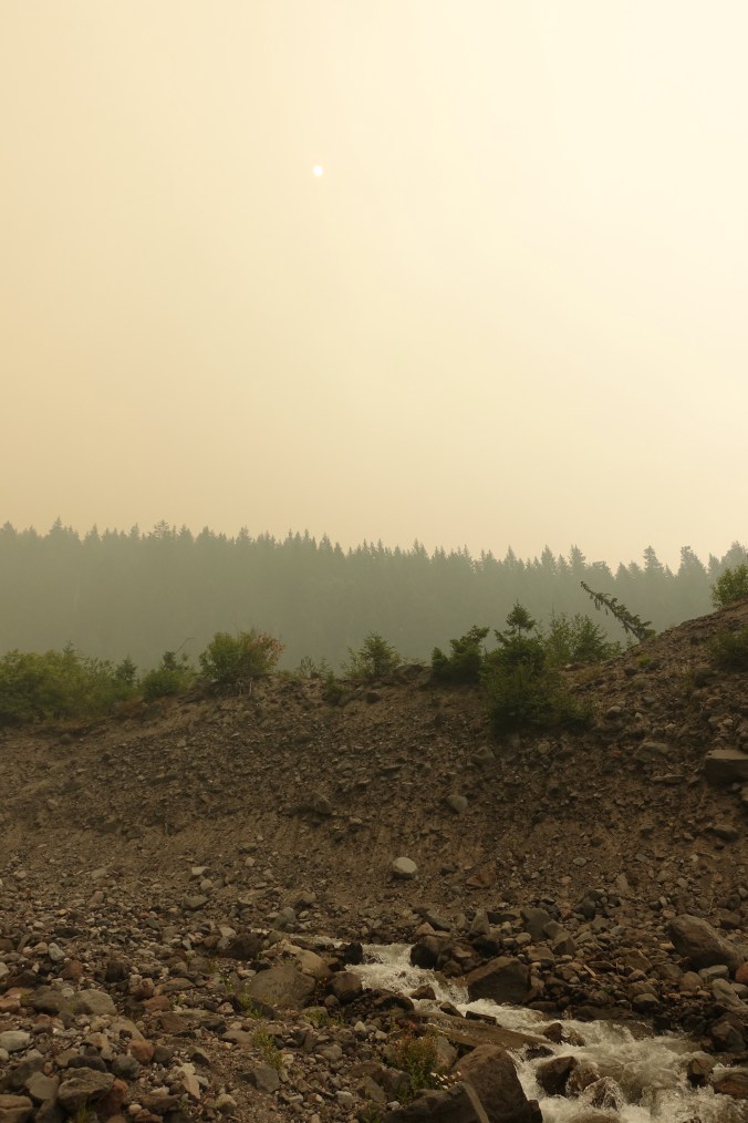
It was difficult to capture, but the sun was obscured by the smoke and faintly glowing red.
About 0.3 miles from the turnoff we ran into a young woman hiking south. We tried asking her about the fire reroute, but I don’t think her English was very good. We couldn’t even figure out if she’d walked the reroute or stayed on the PCT itself (which is closed). She did tell us that the quarter mile of trail before the turnoff was worse, but we just assumed she meant the smoke. We continued on.

The ground is still smoldering!

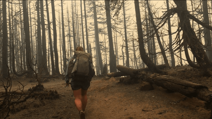
Soon the green shrubbery around the trail became smoking ashes. The smoke was no longer up ahead. It was now around us. I quickened my pace, hoping that the Woodpecker Ridge trail would take us away from the smoldering forest floor. There was no sign at the junction, just a post. The sign had burned down. Looking around, it was readily apparent that this entire area had recently burned. We’d gone from a green forest to a ghostly burn zone.
Approaching our turnoff.

We ended up with very few pictures from the burn zone… probably because we were trying not to freak out!
I headed a few feet down Woodpecker Ridge trail only to discover that it had burned as well. Smoke was rising from the ground. I could feel the heat of the embers on my legs. Small flames rose from the ashes. I stopped and tried to assess the situation. Should we try to continue to quickly exit the park and hope that it would get better further down the trail? It didn’t look any better up ahead; it looked worse. Should we turn back? The Pamelia Lake junction was less than two miles back and I was pretty sure we could take it to exit the park. I might not have the right permit, but surely this was an extenuating circumstance. As we paused to discuss our options I saw a branch fall near the trail about 50 feet in front of us. Looking up, I realized that what had previously been a heavily forested area was now a potential obstacle course of falling branches. This was not a safe place to be. Decision made. We started hightailing it back to the Pamelia Lake junction.
As we retreated, we ran into Sharkbait and Sap Happy, a couple that we’d been leap frogging with throughout the morning. We told them about the situation ahead and explained that we hadn’t felt comfortable exiting via Woodpecker Ridge Trail. They decided to check it out for themselves and we wished them the best.
Just before the Pamelia Lake junction we had to cross Mill Creek again. It hadn’t been too big of a deal heading north, but the rock hop had ended with a big leap to the other side. Finding a good spot on the way back wasn’t as obvious and I ended up getting a foot wet as I tried to hurry across. Just to cap off my morning I guess.
There was a ranger closing off the PCT at the Pamelia Lake junction. He explained the the fire had significantly expanded overnight and was interested to hear our account of the area around Woodpecker Ridge trail (especially that the trail sign had burned down). He was concerned to hear that there were still two hikers in the area and we gave him our best description of them (although in our panic, we’d completely forgotten their trail names, which they’d first told us the last time we saw them). My instinct that we’d be able to exit on the Pamelia Lake trail despite it’s limited use status turned out to be correct. We were ordered to quickly make our way to the trail head and not stop along the way.
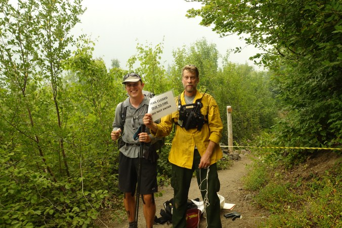
That’s a smile of pure relief.
Having talked to a ranger and being on our way toward the trailhead, the tightness in my chest started to loosen a little. The area was still smokey, but it was easy to see why this side trail warranted special protections. We were surrounded by old-growth trees and lush green undergrowth. I can only hope that they’ll be spared in the fire, but the ranger didn’t sound hopeful. (Update: reports from October indicate that this area did not burn).

It was such a relief to finally reach the trailhead. We were out of danger. I was also starving. It was after 2pm and we hadn’t been able to stop for lunch. Although we’d taken a moment to stuff our side pockets with snacks just before getting back to the Pamelia Lake junction it wasn’t enough. We stopped at a picnic bench to eat and regroup. Michael studied our maps (he’d downloaded the relevant maps in maps.me so we have access to broader maps than available on Guthooks) and I worked on texting back and forth with my dad on our InReach (we’d let him know when we initially turned around). Luckily, we’d ended up on a forest service road (#2246) that would connect with the same road that Woodpecker Ridge Trail would have dropped us on (#040). What we couldn’t figure out was how the overnight expansion in the fire zone would affect where we could get back on the trail (the ranger told us that all of Mt. Jefferson Wilderness was closing). Ultimately, we decided that our best option was to start walking and figure out the rest of the logistics when we could get online.
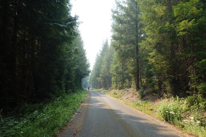
Despite being offered a ride by the ranger, we opted to hike the forest road. Our plan had been to hike around the forest closure and the fact that we’d basically run into the fire wasn’t going to change that (the ranger said it was okay safety-wise). The forest road had been shut down to civilian car traffic, so it was a fairly stress-free hike out to the main road. A nice way to decompress after this morning’s dramatic turn of events. And there was a nice forest service woman waiting at the end of the road with cold water! She checked us off her evacuation list and we turned onto Highway 22.
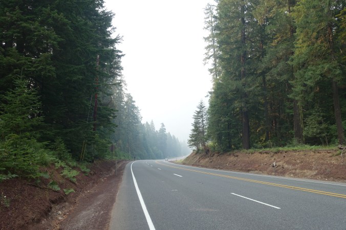
Where the forest service road was an easy stroll with few distractions, walking along the edge of Highway 22 was a nerve-wracking experience. By this point in the afternoon I was tired, both physically and emotionally. My feet hurt from walking on the hard pavement and my left shoulder was killing me. My hope this morning that we might be able to get to the little town of Detroit for the night was now dashed — we’d lost too much time in the chaos of running into the fire and I had been unrealistic as to how fast and easy the road walk would be. Cars continually rushed past us. The road has a shoulder, but isn’t wide enough to comfortable walk along so I found myself trying to constantly walk on the steeply slanted ground next to it. Not fun. The only bright spot was a couple that had pulled their RV over in a pull-off and greeted us with cold sodas. A much needed pick-me-up in an otherwise dreary afternoon.

We ended up stopping for the night at the Whispering Falls campground. It was a typical national park campground that luckily had a few spots still available (but none tomorrow for any other poor hikers coming through!). We asked the camp hosts if there were any other PCT hikers staying here and it was clear they weren’t familiar with the PCT. No hikers have been through here. When the camp hosts heard more about what we’ve been up to they kindly refused to accept payment for our camp spot and even offered free fire wood (which we are too exhausted to accept).
My cell signal isn’t good enough to get online, but I was able to call my Dad to check on the status of the fire closure. Although the park ranger told us that the Mt. Jefferson Wilderness was closing, my Dad reported that the fire closure information online hasn’t changed since we left Bend — it still advises hikers to exit at Woodpecker Ridge trail even though the trail has clearly been closed before that point! What we can’t figure out is where the fire closure ends. The reroute instructions that we were following say that we should get back on trail at Breitenbush Lake via Forest Road 4220. The problem is that road 4220 is the park boundary, so we have no idea if it will be open. If it’s closed, I think we’d have to walk all the way to Olallie Lake, which isn’t particularly straightforward due to the way the road twists and turns.
To say that I’m frustrated (and tired and cranky) is an understatement. As it is, we likely won’t finish this miserable road walk tomorrow. Camping options along the road are limited and the next highway (46) sounds like it has no shoulder. My shoulder is killing me — taking off my shirt turned into a monumental challenge because raising my arm above my head hurts so badly. We considered just ditching this camp spot and trying to hitch to Detroit, but ultimately decided that we’ll get up early in the morning to walk there (hopefully beating much of the traffic) and try to use the internet there to further research the closure. I’m questioning our decision to walk all the way around the closure at this point. Although continuous footsteps has always been my goal, today’s road walk was absolutely miserable and I’m nervous about our overall timing. We’ll make the final call tomorrow with fresh eyes.
Not my favorite day on trail. Also, when Michael went to wash off his legs this evening, he discovered that underneath a patch of soot his hair had been singed off! Too much drama for the day. I had always wondered whether I would be too stubborn to turn back if trail conditions were too dangerous. I guess I got my answer today.
Current ailments:
Elizabeth: left shoulder killing me, sore feet
Michael: sore feet, hurt eyes, and apparently a burn just above my ankle.

Nice pictures. Great backpacking 😀
LikeLiked by 1 person
Wow… That sounds like one day you won’t soon forget!! Hopefully it’ll seem like an adventure looking back on it.
LikeLiked by 1 person
Yep, it was a memorable one!
LikeLike
This sounds like one of your most memorable days on the trail. Wow.
LikeLiked by 1 person
It definitely stands out! Not the most relaxing though.
LikeLiked by 1 person