Day 113: Cascade Locks!

August 8, 2017

Total daily miles: 14.8 miles

Total PCT miles: 1737.5

Start: mile 2129.6

End: Cascade Locks (mile 2144.4)

Total elevation gain/loss: 1495.4/5537.4 ft

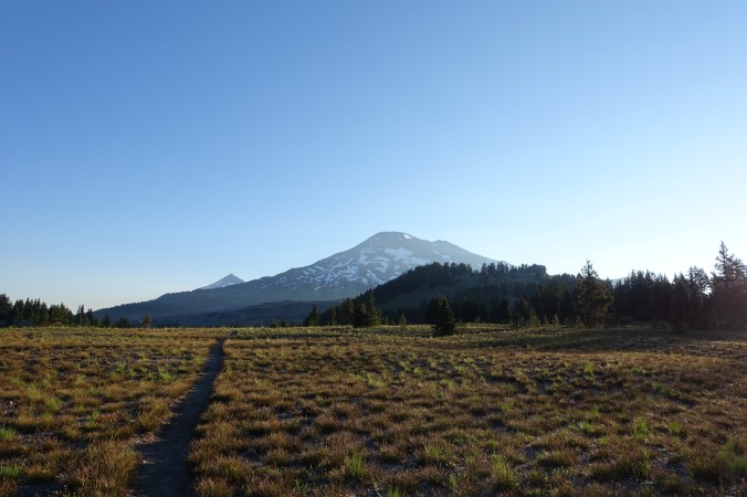
After yesterday’s unexpected long day, we treated ourselves this morning and “slept in” until about 6am.  It’s a town day — only 15 miles to Cascade Locks!  Even better was the prospect that most of it was downhill.  Dreams of a town lunch danced in my head as I packed up camp.

DSC03928DSC03929

Most of today’s hike kept us tucked away in the trees, although we did hit a few areas of open ridge line early in the morning.  Unfortunately, the haze is even worse today than it was yesterday so our views were obscured. Continue reading

Day 112: A Forced 30

August 7, 2017

Total daily miles: 30.0 miles

Total PCT miles: 1722.7

Start: mile 2099.6

End: mile 2129.6

Total elevation gain/loss: 5323.2/6481.6 ft

Well, another day that didn’t quite go as planned…  We started out this morning in what felt like a foggy haze.  I’m assuming that it was smoke from the Eagle Creek fire, but with fires both north and south of us now it’s hard to know for certain.

dsc03906

Our first couple of miles were all downhill.  We had a great view of a large waterfall in the distance, otherwise it felt like we were walking through an area that has seen a lot of erosion/rock slides.  Lots of exposed dirt cliffs!  After a few miles we hit the Sandy River (with a name like that we figured we wouldn’t be grabbing water from this source).  I’d seen some mixed info about how hard of a crossing it was, so I was pleased to see that it wasn’t the fast, thigh-high crossing that was reported.  Just a log crossing!  And by “just,” I mean that the logs were relatively narrow and I was super happy to have my poles, but I made it across with dry feet.  I’ll take it as a win. Continue reading

Day 111: Stuffed on a Timberline Breakfast!

August 6, 2017

Total daily miles: 15.5 miles

Total PCT miles: 1692.7

Start: mile 2084

End: mile 2099.6

Total elevation gain/loss: 3482.9/2044.9 ft

We were up and hiking before the sun was up this morning.  Normally, I wouldn’t be thrilled about the prospect of starting my hiking day with the aid of a headlamp.  But today wasn’t a normal day.  Today, I knew that every minute I hiked in the dark was an extra minute to enjoy the Timberline Lodge buffet breakfast!

dsc03889

Early morning road crossing

We had just over ten miles until the Timberline Lodge.  But of course, just to make things more challenging, we also had about a 2000 foot elevation gain over the last five miles.  Fun!  As I set off in the dark, I was grateful that the path seemed wide and well-defined.  It was much easier to navigate and walk quickly than some of the night hiking we’ve done along steep hillsides.  We largely stayed in the trees, although since it was dark for the first couple of miles I guess I wouldn’t know if I missed a great view anyway. Continue reading

Day 110: 32 Miles!

August 5, 2017

Total daily miles: 31.9 miles

Total PCT miles: 1677.1

Start: mile 2052.1

End: mile 2084

Total elevation gain/loss: 3613.2/4064 ft

A record day for us!  Almost 32 miles!  I guess the pull of an all-you-can-eat breakfast buffet is a strong one.

dsc03875

This morning’s hike was relatively quiet, with few hikers crossing our path.  I guess everyone stayed at Olallie Lake last night hoping for trail magic.  It felt like we spent most of the morning in the trees, with a few patches of open grasslands dispersed in between.  It was a great morning for cruising, with only a couple minor climbs that were relatively well graded.  I hiked with determination, knowing that we only had 42 miles to hike before arriving at the Timberline Lodge and its legendary breakfast buffet. Continue reading

Day 109: Finishing the Mt. Jefferson Reroute

August 4, 2017

Total daily miles: 25.8 miles (15.1 miles PCT; 8.7 miles Hwy 22; 2 miles FR 4220)

Total PCT miles: 1645.2

Start: Whispering Falls Campground/Woodpecker Ridge Trail (mile 2026.8)

End: mile 2052.1

Total elevation gain/loss: 1366.8/2597.4 ft (PCT section only)

Today we faced the difficult decision of what to do about the fire reroute.  But first, figuring out what the fire reroute is after yesterday’s news that the entire Mt. Jefferson Wilderness is being (has been?) closed.  Easier said than done.

dsc03861

Our morning view.

Continue reading

Day 108: Too Close to the Fire

August 3, 2017

Total daily miles: 26.7 miles

Total PCT miles: 1619.9

Start: Rockpile Lake (mile 2012.3)

End: Whispering Falls Campground/Woodpecker Ridge Trail (mile 2026.8)

Total elevation gain/loss: 1935.7/3869.8 ft (PCT section only)

What a day!  Today did not go as planned.  Trying to get around the fire in the Mt. Jefferson Wilderness has left me physically and emotionally exhausted.  It’s one of the few days on trail where I feel like I could cry at the end of it.  This is a long one…

We got up extra early this morning with the hope of getting out of the smoke and on the fire alternate as quickly as possible.  The air was clearer this morning then it was last night.  I hoped that was a good sign of things to come.

dsc03841dsc03843

Continue reading

Day 107: Smokey Santiam Pass

August 2, 2017

Total daily miles: 13.9 miles

Total PCT miles: 1605.4

Start: Santiam Pass (mile 1998.4)

End: Rockpile Lake (mile 2012.3)

Total elevation gain/loss: 2910.4/1450.1 ft

I’ve learned enough by now to know that getting out of town is never fast and today was no different.  We said goodbye to Renee, who has been an awesome host.  She’s been so nice and full of energy, it’s been great to get to know her a bit.  Again, future hikers should definitely check out Recharge, especially if you’re in town during beer yoga!

dsc03825

Playtime with a dog makes Michael’s day.

Continue reading

Day 105: Bend Trail Magic

July 31, 2017

Total daily miles: 16.7 miles

Total PCT miles: 1291.5

Start: mile 1981.7

End: Santiam Pass (mile 1998.4)

Total elevation gain/loss: 1961/2371.4 ft

Despite being near the highway, I slept really well last night.  The best part was that my feet felt much better as we got going this morning than they did last night!  Which was a good thing, since we started with a stretch over more lava rock.

dsc03817

The other good news this morning is that the lava section was much shorter than I had feared.  Based on our map, it looked like we’d spend several miles walking over lava, but it ended up being a much shorter stint with much smaller lava rock than the end of the day yesterday.  It was still a slow start to the day and I was definitely happy to have waited, but it was over within a couple of miles and we largely stayed in the shade. Continue reading

Day 104: A Beautiful Day in Three Sisters Wilderness

July 30, 2017

Total daily miles: 25.4 miles

Total PCT miles: 1574.8

Start: Sisters Mirror Lake (mile 1956.2)

End: mile 1981.7

Total elevation gain/loss: 3369.1/4159.8 ft

Today was awesome!  Probably one of the most beautiful days that we’ve had on the trail.  There were so many magical moments — my day in Three Sisters Wilderness is not one that I’ll soon forget!  I couldn’t stop taking pictures, so this will be a photo-heavy post.

org_dsc03784

The morning mist on Sisters Mirror Lake.

org_dsc03785

We had a little haze throughout the day, but otherwise it was beautiful!

org_dsc03787

Continue reading