by Elizabeth
After arriving back in Marrakech on our early morning bus from Essaouira, we turned around and hopped in a private van headed for Imlil. We had identified Imlil, a small town in the High Atlas Mountains, as a good base for trekking in Toubkal National Park. Although we typically prefer hiking on our own (and had a particularly odd experience using a guide in the Indian Himalayans), our limited research suggested that organizing and navigating a multi-day hike on our own would be difficult.
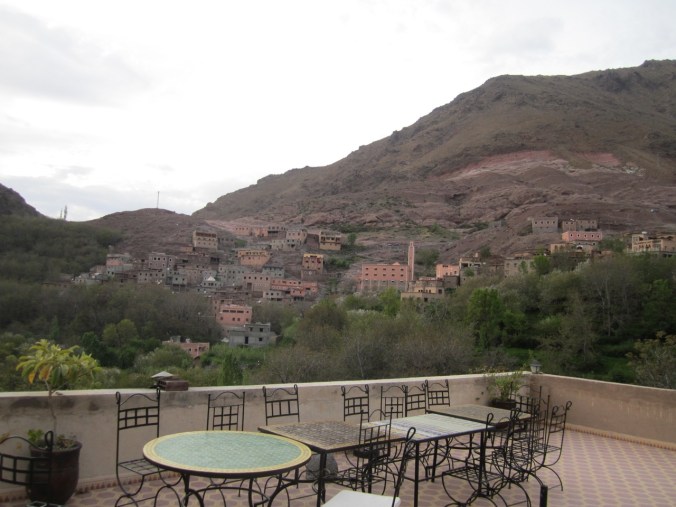
The wonderful view from the terrace of our first riad in Imlil.
Our initial interest was to focus on hiking in the valleys and visiting the local Berber villages. However, after speaking with a few trekking operators, we became worried that the daily mileage for these treks would be too low and that we’d be arriving at our destinations early in the day. Part of the problem was that it was difficult to tell how long any hike was because no one could give us information regarding distance and instead only gave hiking time (which we came to learn included long stops for lunch). Our attempts at explaining that we were used to hiking long days in the Sierra mountains did not seem to change any of the operators proposed itineraries and we simply hadn’t done enough front-end research to propose alternatives. We ultimately ended up signing on to do exactly what we’d told ourselves we wouldn’t — summit Mount Toubkal (13,671 feet), the highest peak in Northern Africa. Instead of heading straight there, we added a day on the front end of the hike to visit one of the neighboring and then cross over a nearby pass.

Small hammam (traditional Moroccan bath) behind one of the Berber residences that we passed on the first day of our trek.
On the first day of our trek, we met our guide (Ibrahim) and mule driver/cook (Hassan) (seriously, we couldn’t find any three-day trekking option without a mule). Ibrahim helped us navigate the many trails surrounding Imlil and we began the day by heading up a small pass separating Imlil and one of the neighboring valleys. In what would become a theme, there was a small stand at the top of the pass selling soft drinks and fresh orange juice (and we hadn’t even been hiking for two hours yet). Shortly after the pass, we stopped for lunch. We sat in the shade on padded cushions and ate the three-course meal that Hussan had prepared — not at all like the rehydrated refried beans and Fritos lunches that we had become accustomed to the John Muir Trail last summer.

Several goats crept up behind us to say hello as we were enjoying the tea served at the end of our lunch.
After lunch, we hiked for another hour before arriving at the hiker’s refuge that we would spend the night at. Ibrahim looked surprised when we told him that we would continue to hike on our own to explore the valley that afternoon (we’d only actually hiked for 3.5 hours at that point!). We enjoyed hiking up one of the streams through the canyon in the direction of a small waterfalls, stopping to purify water along the way.

View hiking down to our first refuge.
The refuge was not as we had envisioned it would be. It was large and modern, with indoor plumbing and cooking facilities for the guides. It was also almost empty — there was an extended French family and eventually a Polish couple — so we did not have to share our room with anyone (the room had two sets of double-sized bunk beds).

Waterfall along the way up the pass on day two.
Our second day we left at 6am and hiked up to a large waterfall (60 meters high) and then up a high pass (at about 11,000 feet). To reach the pass we went up an extensive set of switchbacks (more than the JMT’s famed Golden Staircase I think) and across a large patch of snow. While I was easily able to zoom up the mountain, Michael had more difficulty with the ascent (though he can run downhill much faster than me).

Michael heading up the set of switchbacks (you can see them heading all the way down if you look closely).

Crossing one of the large patches of snow (which is why Hassan and the mule had to take a different route on day two). Ibrahim referred to our ridiculous hats with removable neck-flaps as “American turbans.” May not be stylish, but the trails were completely exposed and they saved our necks.
We stopped for an early lunch on the other side of the pass (after crossing more snow) before arriving at the next refuge by 12:30 (reinforcing our concern about the short hiking days). The second refuge was much large than the first and was crawling with large mountaineering groups that were equipped with huge bags. We watched as the groups returned from summiting Toubkal and new groups arrived direct from Imlil. The place ended up being packed that evening — every bed was taken and some people had to sleep in the common areas (there were easily over 100 people and this did not count the neighboring refuge). We ran into a couple of Americans, but otherwise it was mainly large French/Dutch/Spanish groups.

Heading down to the second refuge that was populated by the large mountaineering groups.
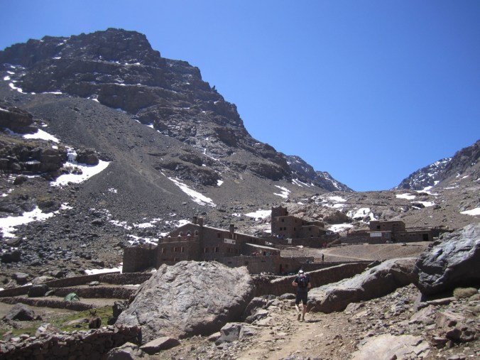
The refuges below Toubkal. We stayed at the upper one.
On our third day we headed out just after 5am and started up the mountain in the dark. While this sounds early, we could see the headlamps of the many groups that had started before us going up the mountain. I actually enjoy hiking in the dark — I get to enjoy the beauty of the gradual transition to light and allows me to focus on the hiking with no distractions. The early morning hiking was one of the times that I was most happy to have a guide, as there were many trails up the mountain likely due to a combination of poor trail maintenance, varying snow conditions, and people taking shortcuts up and down the mountain. At one point, Ibrahim took us on an alternate route that both allowed us to pass a couple large groups and avoided a slippery section across the snow/ice. While it didn’t feel like we were hiking particularly quickly, we made good time and only took short breaks (otherwise we would get to cold) and were therefore able to pass many of the groups that had started before us. When we arrived at the summit at 7:30am, there were only a few people up there and we could enjoy the top in relative peace.

The first glimpses of sunlight hitting the mountain range.

We made it!
Unlike the top of Mt. Whitney, where we froze, the summit of Toubkal wasn’t horribly cold (although the section immediately before it was freezing). Summiting after sunrise probably helped.
Unfortunately, hiking up Toubkal also meant that we had to hike down it. The scree (loose rocks) and steep trails made this extremely difficult. We both managed to have impressive falls (we’re ok) and we were pretty slow going (we descended only 10 minutes faster than we ascended). I was jealous when I saw one of the Americans we met that prior afternoon running down the mountain! Back at the refuge, we relaxed for awhile, then had lunch before hiking another 3.5 hours back down the mountain to Imlil. So much downhill in one day! I seriously would have rather climbed up the mountain a second time in exchange for having to hike down it! While I really enjoyed the ascent, the descent was not fun in my opinion (reminding me of Whitney Portal).
Back in Imlil, we had the luck of being transferred to a different accommodation because the first place we stayed at was booked. The new place (Atlas Imoula) had only opened the month before and was a pleasant upgrade for relaxing after our hike.

Another gratuitous shot of one of the amazing views we were treated to!
Despite our initial hesitance to use a guide, on the whole I am glad that we did so. The route that we took was difficult to navigate at times, in part due to the extensive series of goat paths up and down the mountain that are used daily by the local Berber herders. Having someone who knew there way and all of the little tricks (including when to hike the passes to avoid falling rocks from the goats passing above) was helpful. Hiring the guide and mule driver/cook was also economical (about $100 total per day, including accommodations in the refuges and meals). That said, it was at times a bit frustrating. We are used to putting in significant mileage in a day and keeping a pretty good, steady pace. We spent a while trying to convince Ibrahim that we were serious hikers and that we were used to this type of terrain (he still refused to believe that we hiked the equivalent of 30km in a day on the JMT with serious elevation gain). We are also used to having our own maps and using them to track our progress. Ibrahim at times would refuse to give us information about what lay ahead (such as refusing to tell us how long he expected it will take us to reach the summit when we spoke the evening before), or would flat-out lie (such as telling us that it was 30 minutes to the top of the summit, when my guess of 2 hours was closer to the actual time at that point). I expect that he did this because some hikers might become easily discouraged, but that’s not how we operate (in fact, full information allows us to better plan our pace and appropriate timing for breaks). While the pros outweighed the cons, having a guide was a reminder of certain aspects of independent backcountry backpacking that we enjoy — full control of, and responsibility for, our hike.
