PCT Resupply Prep

by Elizabeth

When people hear that we’re planning to hike the PCT, they often ask: What are you going to eat on the PCT?  How are you going to get food?  Do you carry all of your food in your pack?

It turns out that planning and executing our PCT resupply strategy ended up taking a significant portion of our 2.5 weeks back in California before hitting the trail.  There was only so much that we could plan from abroad — we developed a general strategy and then left the rest for later.

IMG_0007

Packing resupply boxes is tough work. Also, Sierra* helped.

Continue reading

Hiking in Taiwan

by Michael

In case you haven’t caught on yet, we like to hike. And with only about a month to go before starting on the PCT we were on the hunt for good training hikes. In many countries, we found that hikes were often too short and required a guide. Taiwan is more known for hikes, and we had some good outings, but it was still difficult to find good long hikes. Ultimately the best hikes we found were around Taipei.

DSC01217

We were unable to hike in the high mountains during our visit. The notable hikes require permits obtained weeks in advance, and the weather/snowpack was not conducive to our visiting anyway. So we did shorter hikes around Taipei, Taroko Gorge, and Alishan. We also did long walks on bike paths in Hualien on the East Coast and Tainan in the West.

Continue reading

Our (Temporary) Return

by Michael

“You could travel the world, but nothing comes close to the golden coast”

-Katy Perry

After more than 11 months of international travel, we safely returned to the United States on March 28, 2017. On our flight from Taipei to Los Angeles we had an unexpected night-time view of the San Francisco Bay Area, which I have tried to make more visible with filters:

IMG_2966

Not the best photo, I know. But it was a nice view of our home after almost a year away.

Continue reading

Sagada: Hanging Coffins, Squeezing Through Caves, and Beer!

by Elizabeth

Described by Lonely Planet as “the closest thing that the Philippines as to a Southeast Asian backpacker mecca,” we were excited to head north from Baguio to the small town of Sagada to fit in some more mountain hiking.  We hopped off our 5-hour bus ride and started looking for a place to stay for the night.

DSC01046

Looking down on the small town of Sagada.

Continue reading

Trail Report from the Mt. Ulap Eco-Trail (aka the Philex Ridge Trail)

by Elizabeth

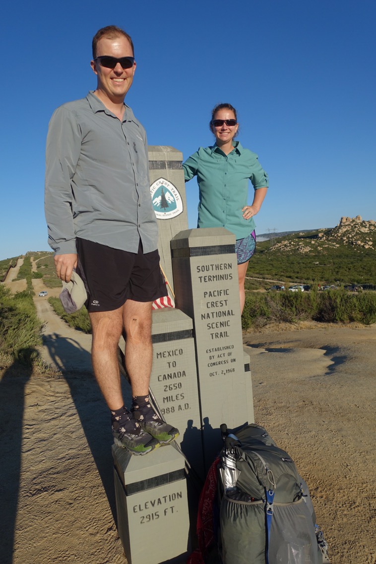
The Mt. Ulap Eco-Trail ended up being my favorite hike from our one-month trip to the Philippines.  It has the winning combination of great views, some nice climbs, and decent trail.  Unfortunately, figuring out some of the practical information about the trail, such as how to get to the trail head using public transportation, ended up being a bit of a challenge.  I’ve included some of those details in this post in case others may find it helpful.

Despite my difficulty finding helpful logistical information regarding the trail, it turns out that the trail is really popular.  There is a cap on how many people can hike the trail each day (I believe it is 500), and on weekends the trail is packed.  We visited on a weekday and saw several groups out on the trail.  Being only two hikers, we were the oddball group.  Filipinos appear to hike/travel primarily in large groups.

As an initial note, one of the things that I found most confusing about the trail was its name.  Is it the Mt. Ulap Eco-Trail or the Philex Ridge Trail?  Are those the same trail or different trails?  As far as I can piece together, the official name of the trail is the “Mt. Ulap Eco-Trail.”  Public access to and regulation of the trail appears to be relatively new (October 2015), so the flashy name may be as well.  All reports that I’ve seen of the Philex Ridge Trail describe the exact same trail, so I believe that it is actually an alternate name that refers to the same trail, or at least a portion of the same trail (maps.me shows Philex Ridge Trail possibly extending further than the Mt. Ulap Eco-Trail).

Getting There

The Mt. Ulap Eco-Trail begins near Ampucao National High School in Itogon.  We were staying in Baguio and wanted to take public transportation instead of hiring a driver or joining a tour.  We caught a jeepney on Lakandula street (which is more of a parking lot behind the Jollibee) that had an Ampucao signboard.  Other signboards might read Itogon or Philex Mines, but it’s best to confirm that they’re going to the right spot.  I confirmed with the jeepney “manager” (the guy yelling the destination, not the driver) that the jeepney was headed to Itogon.  This wasn’t specific enough for him — he clarified that the jeepney was going to Mt. Ulap.  I think that this is because Itogon is the region.  As it turns out, the trail is well known amongst the jeepney drivers for this route so it’s easiest to clarify that you’re going to Mt. Ulap.  I believe that you can also catch a jeepney on Calderon Street near Burnham Park (this is where we were dropped off at the end of the day by our taxi).

We waited about 45 minutes for our jeepney to fill up and head out to Ampucao.  I had pinned what I thought was the school where trail registration occurs on maps.me, so when after 30 minutes or so our jeepney turned onto a different road we became a bit concerned.  It turns out that I pinned the wrong location (in a town called Itogon, which is in a completely different location) and that while maps.me does show the “Philex Ridge Trail” it did not show the school or town where the trail begins.  Luckily, basically everyone in our jeepney was headed for the hike and the drivers know where to drop you for the Mt. Ulap trail.  I believe we paid about Php. 30 ($0.60) each for the 45 minute ride.

The jeepney dropped us off at an intersection marked with these signs:

Continue reading

Hitting the Hiking Trails in Baguio

by Elizabeth

Drawn by rumors of cooler weather and mountain hiking trails, we opted to head north from Manila to the North Luzon region instead of immediately jumping on the more traditional island-hoping tourist trail.  We couldn’t figure out how to purchase a bus ticket in advance (without trekking through heavy traffic to the bus company’s terminal) so we took our chances and showed up at the Victory Liner terminal when we were ready to head north.  We lucked out and scored seats on a VIP bus headed straight to Baguio.  With only three seats across and an onboard toilet (meaning we did not stop for the entire 5-hour journey), we felt like we were living a life of luxury.

The rumors about the weather turned out to be true — it was actually chilly when we got off the bus!  No wonder Baguio was used as the summer capital during the American colonial period.  Our first morning in Baguio we headed to City Hall upon the advice of our hotel to find the tourist office.

IMG_2664

Continue reading

A Short Stop in the Cameron Highlands

by Michael

The Cameron Highlands in Malaysia are known for cooler weather, tea plantations, strawberry fields, and a great system of numbered hiking trails. We initially booked only two nights in the small town of Tanah Rata in the Cameron Highlands. We thought we might stay longer if the weather was good enough for hiking. Well, the weather was good enough, but the authorities had closed most of the trails because of the rainy season. We made the most of our full day (we had arrived at night) but with the risk of getting a ticket for hiking, we moved on to Kuala Lumpur on the second morning.

img_2627

The path less traveled. Because it’s closed.

Continue reading