by Elizabeth
The Mt. Ulap Eco-Trail ended up being my favorite hike from our one-month trip to the Philippines. It has the winning combination of great views, some nice climbs, and decent trail. Unfortunately, figuring out some of the practical information about the trail, such as how to get to the trail head using public transportation, ended up being a bit of a challenge. I’ve included some of those details in this post in case others may find it helpful.
Despite my difficulty finding helpful logistical information regarding the trail, it turns out that the trail is really popular. There is a cap on how many people can hike the trail each day (I believe it is 500), and on weekends the trail is packed. We visited on a weekday and saw several groups out on the trail. Being only two hikers, we were the oddball group. Filipinos appear to hike/travel primarily in large groups.
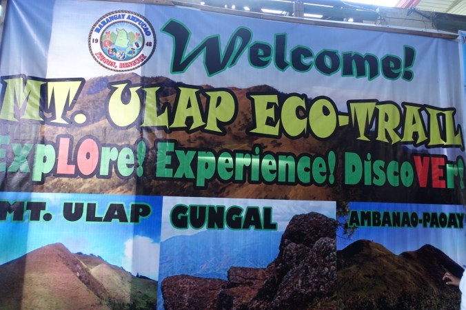
As an initial note, one of the things that I found most confusing about the trail was its name. Is it the Mt. Ulap Eco-Trail or the Philex Ridge Trail? Are those the same trail or different trails? As far as I can piece together, the official name of the trail is the “Mt. Ulap Eco-Trail.” Public access to and regulation of the trail appears to be relatively new (October 2015), so the flashy name may be as well. All reports that I’ve seen of the Philex Ridge Trail describe the exact same trail, so I believe that it is actually an alternate name that refers to the same trail, or at least a portion of the same trail (maps.me shows Philex Ridge Trail possibly extending further than the Mt. Ulap Eco-Trail).
Getting There
The Mt. Ulap Eco-Trail begins near Ampucao National High School in Itogon. We were staying in Baguio and wanted to take public transportation instead of hiring a driver or joining a tour. We caught a jeepney on Lakandula street (which is more of a parking lot behind the Jollibee) that had an Ampucao signboard. Other signboards might read Itogon or Philex Mines, but it’s best to confirm that they’re going to the right spot. I confirmed with the jeepney “manager” (the guy yelling the destination, not the driver) that the jeepney was headed to Itogon. This wasn’t specific enough for him — he clarified that the jeepney was going to Mt. Ulap. I think that this is because Itogon is the region. As it turns out, the trail is well known amongst the jeepney drivers for this route so it’s easiest to clarify that you’re going to Mt. Ulap. I believe that you can also catch a jeepney on Calderon Street near Burnham Park (this is where we were dropped off at the end of the day by our taxi).
We waited about 45 minutes for our jeepney to fill up and head out to Ampucao. I had pinned what I thought was the school where trail registration occurs on maps.me, so when after 30 minutes or so our jeepney turned onto a different road we became a bit concerned. It turns out that I pinned the wrong location (in a town called Itogon, which is in a completely different location) and that while maps.me does show the “Philex Ridge Trail” it did not show the school or town where the trail begins. Luckily, basically everyone in our jeepney was headed for the hike and the drivers know where to drop you for the Mt. Ulap trail. I believe we paid about Php. 30 ($0.60) each for the 45 minute ride.
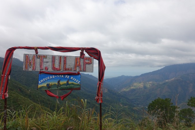
The jeepney dropped us off at an intersection marked with these signs:


We then walked a few minutes down the road (away from the trail for anyone checking gps/maps.me) to the school. Registration for the hike is actually on school grounds in the open-air auditorium area.

View of the covered school auditorium area from above.
Fees/Guides
Guides are required by the municipality to hike the Mt. Ulap Eco-Trail. I don’t think that the trail necessarily warrants the requirement as the trail is fairly easy to follow for the most part, but it is a popular enough trail that you would likely be approached and questioned by one of the other guides on the trail (I’m not sure what the repercussion beyond this would be). Guides are hired/assigned on the spot at the school auditorium, so this is not something that you have to figure out in advance.
The fee schedule was revised in January 2017, so fees were higher than I had expected. There is now a per person fee in addition to the guiding fee. We paid Php 100 ($2) each, plus Php 600 ($12) for our guide, for a total of Php 800 ($16). Not a bad price overall, but about double what I expected.

Posted fee schedule
After paying our fees, we were stamped and introduced to our guide.
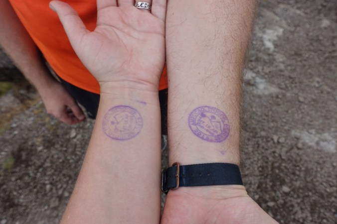
Proof of payment.
Trail Details
Armed with our stamped forearms and a guide, it was finally time to hike!

Sign with brief overview of the hike near the trail head.
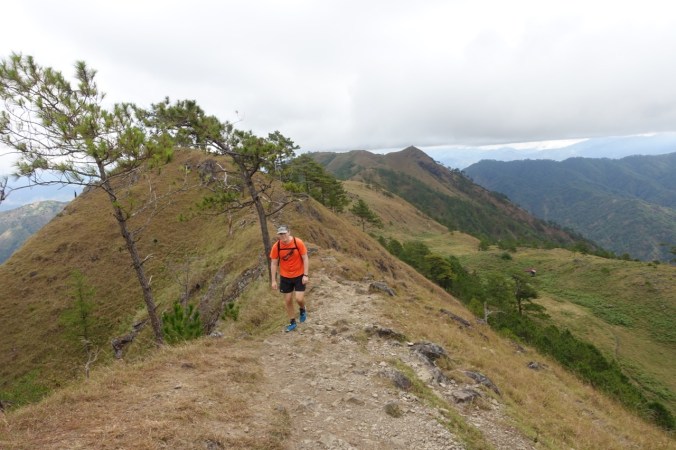
The Mt. Ulap Eco-Trail is known for its fabulous ridge walks and views. Perhaps unsurprisingly, this means that you start with a decent climb up the mountain towards the first summit (Ambanao Paoay). It was overcast on the day that we hiked the trail — perfect for a climb (at least for us, our guide found it rather chilly). I can only imagine that it would be a fairly exposed climb if the sun is out.
Required photo stop apparently. Our guide pointed out basically every spot people like to take pictures and seemed a bit confused when we passed on some of the spots.
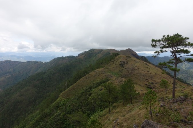
Great view!
I won’t bore everyone with a play-by-play of the hike itself, except to note a few details/highlights.
Trail conditions: For the most part, the trail was a nice, packed-dirt trail with decent grading. There were sections on the final descent (particularly coming down from the Mt. Ulap summit) that were overly steep and slippery. Due to the high levels of traffic on the trail, these areas will be subject to significant erosion over the coming years if they don’t do anything to address the problem now.

Lovely, graded dirt track on the way up.

Ascent/Descent: I don’t have any exact numbers on the amount of ascent/descent for the trail. The trail starts with a climb up to the ridge line and then ascends/descends each of the three peaks. It’s worth noting that the final descent is longer than I anticipated based on the length of the original ascent. The trail ends at a significantly lower elevation than it starts, making the final descent the worst part of the trail in my opinion.
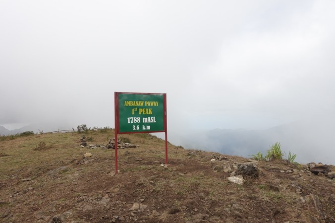
We were a bit misted in for the first peak.


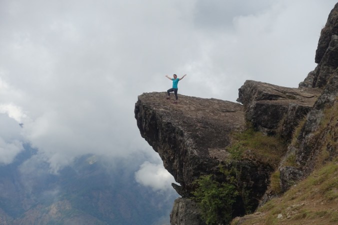
The most popular photo-op on the trail. It’s located just after Mt. Gungal’s peak and requires some careful footing. One of our guide’s few rules was “no jump shots on Gungal.” Sounds good to me. Note that there are no photos of Michael from this spot…
Facilities: There is a “comfort room” or “CR” (term used in the Philippines for a bathroom/toilet) at the high school where you register and at the end of the trail. There is also a primitive one somewhere along trail that your guide can point out (don’t recall where as we didn’t use it). After summiting Mt. Ulap, but before the full ascent, there are a couple spots where you can stop to purchase a beverage/snacks/noodles. These shops also sell “I survived Mt. Ulap” t-shirts if that’s your thing (we passed).

Length: I believe the trail is about 13km long.

Time: I’ve seen reports that it should take about 6-8 hours to hike the full trail. I didn’t note our exact start/end time, but I believe that we hiked for about 4 hours. The longer estimate likely accounts for a fairly slow pace and lots of picture/rest time (a trend we noticed for the large groups). As we were making our final descent we passed a group that had started their hike at 5:30am — a full four hours before we did — and they finished about an hour after us!
Getting Back to Baguio
This is still a bit of a mystery to me. The trail dropped us off on the same road that we started from, but much further down the mountain. We sat and waited along the road for a passing jeepney to take us back to Baguio. While many passed going in the opposite direction, we waited about an hour before one came up the hill in the direction we wanted to go. We stood up to wave it down… and it just passed us by. No clue why.

Looking back up the ravine that we hiked through while waiting for a jeepney.
After one of the large groups finished their hike, we were told by our guide not to worry because a truck had been called to pick everyone up. About 20 minutes later a taxi showed up and we squeezed in along with another couple (leaving the group behind). We were instructed by our guide to pay Php 100 per person ($2) — it ended up being a long enough ride back that I’m sure it wasn’t too big of a surcharge over the metered rate. This is probably the best option for getting back to town if there aren’t any jeepneys coming by (or they aren’t stopping). After waiting around for more than 1.5 hours for a ride, our plans for a late lunch at Good Taste ended up being an early dinner.

Name of one of the jeepneys in Baguio. It’s true.
The Mt. Ulap Eco-Trail traverses some lovely hills and affords magnificent views when the weather cooperates. It was well worth the full day that it took to get there and back independently and the hassle of using a guide.
[This blog post describes our hike on the Mt. Ulap Eco-Trail near Baguio, Philippines on February 8, 2017.]
