by Elizabeth
Drawn by rumors of cooler weather and mountain hiking trails, we opted to head north from Manila to the North Luzon region instead of immediately jumping on the more traditional island-hoping tourist trail. We couldn’t figure out how to purchase a bus ticket in advance (without trekking through heavy traffic to the bus company’s terminal) so we took our chances and showed up at the Victory Liner terminal when we were ready to head north. We lucked out and scored seats on a VIP bus headed straight to Baguio. With only three seats across and an onboard toilet (meaning we did not stop for the entire 5-hour journey), we felt like we were living a life of luxury.
The rumors about the weather turned out to be true — it was actually chilly when we got off the bus! No wonder Baguio was used as the summer capital during the American colonial period. Our first morning in Baguio we headed to City Hall upon the advice of our hotel to find the tourist office.

The place was bustling and the poor people in the main hall had no idea why we thought there might be a tourist office in the building. In an effort to be helpful, the man walked us up to the City Administrator’s Office where we were handed off to another somewhat confused man. The best part was that he did actually have maps of the city and gave us a little overview of the tourist sights. Talk about great service!

I can’t imagine barging into the San Francisco City Administrator’s Office for tourist advice, but the guy here just rolled with it.
Mines View and Camp John Hay, Take One
Two of Baguio’s main attractions are Mines View and Camp John Hay. I couldn’t figure out why they were major attractions from the guidebook descriptions, but we decided to check them out anyway. We took a cab up the Mines View area and found that it was basically a viewpoint off of a street with a bunch of vendors (although we heard that they’ve really cleaned up the area to push the vendors into a more confined area). Supposedly you could see the old mines from the viewpoint (hence the name), but we didn’t spot anything particularly noteworthy. The view was nice though.

Viewpoint area at Mines View. Please note the poor horse with a pink mane and tail. You could tell that it was embarrassed.

View from the Mines View viewpoint.

How could we resist? One of the viewpoint’s permanent fixtures.
From the Mines View area, we opted to walk down to Camp John Hay. On the way we passed the Presidential mansion, which is primarily used in the summer to beat the Manila heat, and neighboring Wright Park.

This is as close as they would allow us to the Presidential Mansion.
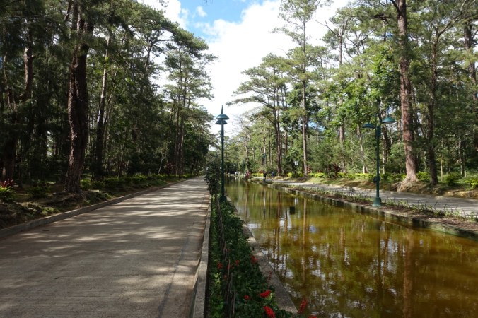
Wright Park gardens.
By the time we got to Camp John Hay, it was around mid-afternoon. The camp was American R&R facility for personnel and their dependents until World War II, when it was used by the Japanese as an internment camp to hold Americans and other Westerners. We’d heard that there might be some hiking trails in the hills around the camp, but only got a nebulous response about a “yellow” trail with a potential use fee when we asked around. Since it was so late in the day, we scrapped the idea of hitting a proper trail and just walked back to town instead. It was too bad we didn’t run Strava because I suspect that we ended up with decent mileage for the day.
Mt. Ulap Eco Trail
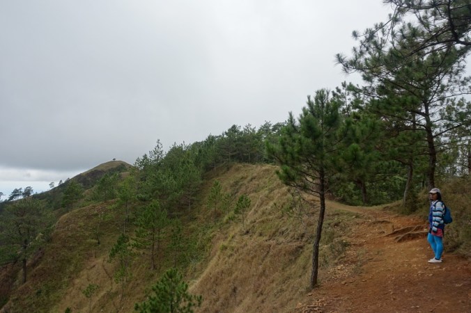
The highlight of our time in Baguio was hiking the Mt. Ulap Eco Trail (sometimes referred to as the Phillex Ridge Trail). Despite the trail’s popularity, it took some digging to find out about the trail and no one that we spoke to in town (including at the tourist office) had any idea that it existed, so I’ll cover some of the logistical details in an upcoming post. Like many of the trails that we encountered in the Philippines, this one required that we hire an official guide. Our guide ended up being a sweet young woman who stayed bundled up for most of the hike in a sweater and gloves (commenting on how cold it was) as we trudged along in t-shirts.
The hike led us up three separate mountains, Ambanao Paoay (1788m/5866ft), Gungal (1814m/5951ft), and Ulap (1846m/6056ft), via a beautiful ridge line trail. We lucked out and managed to enjoy some wonderful views despite the cloud cover. It ended up being a beautiful half-day hike (that took a full day due to logistics).
Our guide, all bundled up!
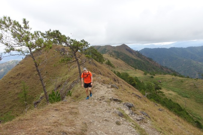
The classic viewpoint for the trail.

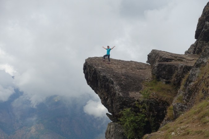
At the top! We managed to summit during a brief moment of sunlight. Little did we know that we’d pass little souvenir stands selling “I survived Mt. Ulap” t-shirts, which seemed a bit much all things considered.
Camp John Hay, Take Two
For a couple of reasons we ended up back in Baguio the following week and had a chance to hit up Camp John Hay a second time for some more hiking. We made a second attempt to find the “yellow” or eco trail after having stumbled upon a helpful gentleman at a slightly more official tourist office in town. We knew it started near a treetop adventures company (think zip lines and giant swings) and received some vague directions from one of the employees (but at least they didn’t charge us a use fee!). The trail headed out under the various zip lines and then abruptly ended…

Of course, we ignored the sign and kept going. After another ten minutes or so the trail actually did dead end onto a road and we turned back. It was disappointing how short the trail was, so we searched around a bit more and finally found a couple of tracks nearby on maps.me. Turns out that we had headed in the wrong direction from the zip line company and should have taken a drainage path instead to the actual trail.


The trails circled the US Embassy grounds (specifically the American Residence — the Embassy proper is in Manila).
It was great to be back on a nice dirt trail under the pines! We ended up doing a couple loops on the trails to rack up some distance since the trail was still relatively short, but it was better than nothing. We have to get in our PCT training somehow!
Good Taste
No blog post of our trip to Baguio would be complete without a nod to our many trips to Good Taste. This multi-floor (I think six?) eating establishment appeared to cater to large families and was nothing fancy. Much of the menu was devoted to family-style dishes that served four or more, but we also tried out some of the more reasonably sized combo meals (costing about $2-3 each). The food wasn’t fancy, just a tasty variety of Filipino favorites and comfort dishes. We tried everything from buttered chicken and lumpia, to tofu and pork belly. We ended up visiting about five times, so it’s sort of sad that I only managed to capture a single photo:

Our only halo halo of our trip to the Philippines.
While the town of Baguio itself was traffic ridden and the streets were filled with exhaust fumes, we enjoyed our glimpse of the beautiful mountains and fresh (naturally pine-scented) surrounding the town. I can see why so many from Manila come up for the weekend.
[This blog post describes our visit to Baguio, Philippines from February 6-9 and 12-14, 2017.]

Thanks for writing. We have just arrived in Baguio today and had been thinking about a hike. Now that’s we’ve read you’re blog I think we’ll just walk out to John Hay and take a look around instead. Leave our hikes to the rice terraces.
LikeLike